Your cart is currently empty!

The Power of Open Source in Earth Science
—
Earth scientists face a constant challenge of turning complex environmental data into fully visualized and accessible content. While researchers make breakthroughs daily in labs and field stations worldwide, too many discoveries remain locked behind academic papers. Those that need the information, and need it quickly, are not always able to access it.
Tethys Geoscience Foundation is changing this through Tethys Platform. By utilizing the power of open-source software, we hope to make both the visualization and sharing of this information accessible to its intended audience.
Breaking Down Barriers
The traditional model of software development has created an impossible situation for many researchers. Annual license fees for base software packages can consume a significant portion of a lab’s budget. This problem hits labs in developing regions particularly hard, where environmental challenges are oftentimes the most urgent.
Open-source platforms offer a different path. Even beyond eliminating licensing costs, they fundamentally change how scientific tools can evolve. When researchers can examine and modify source code themselves, they can adapt tools for their specific needs. This flexibility proves especially valuable during unprecedented environmental events, where existing software may not be equipped to handle current conditions.
From Lab to Field
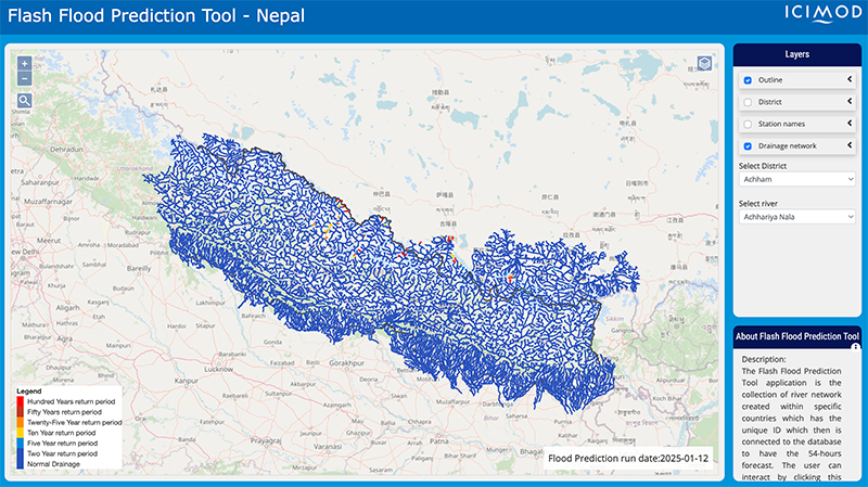
The journey from research and breakthroughs to shareable application is the true highlight of open source in Earth science. In Nepal, for instance, a coalition of scientific organizations developed a Flash Flood Prediction tool. By monitoring over 12,000 river segments they are now able to provide 54-hour flood forecasts. This system was not the result of a single lab. Instead, it represents the combination of multiple open-source technologies, from weather prediction systems to hydraulic models.
This tool truly represents how open-source enables a quick response to local needs. It uses innovative numerical weather prediction and satellite-based precipitation data, processing this information through an open-source hydrological model to generate real-time flood warnings. The system even color-codes river segments based on flood risk, making complex data immediately comprehensible to decision-makers. This kind of specialized interface, built to serve local communities, would be prohibitively expensive to develop using traditional commercial software.
Modern open-source platforms become a bridge we can cross by providing tools that researchers can build upon. By combining analysis capabilities with visualization tools and handling complex geospatial data processing, these platforms let scientists focus on their areas of expertise. Instead of becoming software developers, researchers can concentrate on applying their knowledge to environmental challenges.

Community in Action
The most transformative aspect of open-source development in Earth science is how it enables collaboration. Tools developed for one environmental challenge often prove useful in seemingly unrelated areas. This cross-pollination of ideas happens naturally in the open-source world, where researchers from different disciplines can freely adapt and inform each other’s work.
These unplanned partnerships accelerate scientific progress in ways that weren’t possible under traditional closed-source platforms. Improvements developed in one lab become immediately available worldwide. Solutions created for local environmental challenges can be adapted for similar situations in other regions. This collective approach to tool development multiplies the impact of each innovation.
Technical Freedom and Innovation
The open-source nature of Tethys offers unprecedented flexibility in application development. Scientists can:
- Customize core features for specific research
- Add new technologies as they emerge
- Scale from local studies to global projects
- Build interfaces for different users
- Combine multiple environmental models
Looking Ahead
As Earth science evolves, so do open-source platforms. The continuous development of these platforms is shaped by the real needs of the scientific community, leading to enhanced performance capabilities and increasingly sophisticated visualization techniques. Data handling methods grow more robust and efficient, while integration with emerging technologies ensures that platforms remain at the cutting edge of scientific capability. This organic evolution ensures that the tools remain relevant and effective for addressing current environmental challenges.
Meeting Today’s Challenges
The transition to open-source tools in Earth science isn’t without challenges. Documentation quality varies widely. Integration between different tools can be complex. Some institutions resist changing established workflows. But despite these obstacles, the movement toward open source continues to gain momentum.
The benefits are compelling: research institutions can save substantially on software costs, scientists can adapt tools for local conditions, and most importantly, crucial research tools become accessible to scientists worldwide.
As environmental pressures mount globally, the need for rapid, collaborative scientific progress becomes ever more critical. Open-source development creates the foundation for this kind of collaboration, enabling a future where scientific tools can evolve as quickly as the challenges they address. Through these shared resources and collective effort, the Earth science community is building something powerful.
Together we can create a more responsive, accessible, and effective approach to understanding and protecting our planet.
Want to get more involved? Check out our Linkedin and get updates on all our news and projects.

Leave a Reply