Your cart is currently empty!
Groundwater Management Through Technology
—
Beneath our feet lies one of Earth’s most vital resources. Groundwater provides drinking water for billions of people, sustains agricultural systems, and maintains the base flow of rivers and streams. Yet because groundwater remains largely hidden from view, managing this critical resource presents unique challenges.
Modern technology is transforming groundwater management by making the invisible visible, providing managers with tools to understand, monitor, and protect these essential underground resources.
The Hidden Challenge
Groundwater systems operate on timescales and spatial scales that make them particularly challenging to manage effectively. Unlike surface water, which responds quickly to rainfall and can be observed directly, groundwater changes slowly and requires specialized monitoring to understand its condition. Aquifers may take decades or centuries to recharge, while human activities can deplete them much more rapidly.
This temporal mismatch creates management challenges that traditional approaches struggle to address. By the time conventional monitoring detects problems like excessive depletion or contamination, significant damage may have already occurred. Recovery, when possible, often requires years or decades of careful management.
The spatial complexity of groundwater systems adds another layer of difficulty. Aquifers don’t follow human boundaries, and pumping in one location can affect water levels across vast areas. Understanding these connections requires data and analytical tools that can integrate information across multiple scales.
Technology Enabled Solutions
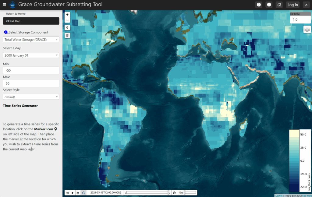
Modern groundwater management increasingly relies on technological solutions that provide comprehensive, timely insights into aquifer conditions. The GRACE Groundwater Subsetting Tool exemplifies this technological transformation. By combining data from NASA’s Gravity Recovery and Climate Experiment (GRACE) satellites with land surface models from the Global Land Data Assimilation System (GLDAS), this application provides groundwater storage change estimates for selected regions.
What makes this tool particularly valuable is its ability to detect changes at scales that traditional monitoring cannot achieve. GRACE satellites measure tiny variations in Earth’s gravitational field caused by changes in water storage, enabling detection of groundwater depletion or recharge across entire aquifer systems. This regional perspective helps managers understand how local pumping affects broader groundwater resources.
The tool transforms complex satellite and model data into accessible visualizations that groundwater managers can readily interpret. Rather than requiring specialized expertise in satellite data analysis, users can focus on understanding what the information means for their specific management decisions.
Filling Critical Data Gaps
Perhaps even more innovative is the Groundwater Data Mapper, which addresses one of groundwater management’s most persistent challenges: incomplete historical records. Many regions lack comprehensive longterm groundwater level data, making it difficult to understand trends or establish sustainable management practices.
This application uses Earth observation data and machine learning techniques to fill gaps in historical groundwater level measurements. By correlating available groundbased observations with satellite data and other environmental variables, the system can estimate groundwater conditions for times and places where direct measurements aren’t available.
This gap filling capability proves particularly valuable for regions where monitoring networks are sparse or where historical records have been lost or never collected. The application enables managers to develop more complete pictures of how their aquifers have responded to past stresses, providing crucial context for current management decisions.
From Monitoring to Management
Effective groundwater management requires more than just monitoring, it demands tools that translate observations into actionable insights. Modern applications accomplish this transformation by connecting groundwater data to the broader environmental and human systems that influence aquifer sustainability.
The integration of multiple data sources proves particularly powerful. When groundwater level data is combined with information about precipitation, land use, and pumping patterns, managers can better understand the factors driving changes in their aquifers. This comprehensive understanding enables more effective interventions and more realistic planning for future conditions.
Visualization tools play a crucial role in this translation process. Complex hydrogeological relationships become more understandable when presented through interactive maps, time series plots, and analytical interfaces that allow managers to explore different scenarios and their implications.
Challenges and Opportunities
Despite their promise, technology enabled groundwater management tools face several challenges. Data quality and availability remain limiting factors in many regions. Satellite based observations provide broad coverage but may lack the spatial resolution needed for local management decisions. Groundbased monitoring provides detailed local information but often lacks regional context.
Integration across different data sources and analytical approaches requires careful attention to uncertainty and validation. Users need to understand the limitations of different data types and how those limitations affect management decisions.
Perhaps most importantly, technological tools must be designed with real management needs in mind. The most sophisticated analytical capabilities provide little value if they don’t address the questions that managers actually face or if they require expertise that managers don’t possess.
Building Sustainable Systems
As groundwater challenges intensify due to population growth and economic development, the need for effective management tools will only increase. Technology enhanced approaches offer pathways for managing these challenges more effectively, but their success depends on thoughtful design and implementation.
Looking forward, continued advancement in satellite technology, machine learning, and data integration techniques will create new opportunities for groundwater management. However, realizing these opportunities will require continued collaboration between technologists and practitioners to ensure that innovations address real management needs.
Through platforms like Tethys, the groundwater management community can continue developing and sharing tools that make this invisible resource more visible and more manageable. As these tools evolve and improve, they offer hope for more sustainable groundwater management that protects this vital resource for future generations.
To learn more about how Tethys applications can support groundwater management in your region, explore our resources and join our community of Earth scientists and water managers working to protect this essential resource.
Leave a Reply