Your cart is currently empty!

Data in Use: Transforming Earth Science Information into Action
—
As we celebrate Earth Day, we’re reminded that environmental stewardship requires not just awareness, but informed action.
In an age of unprecedented data collection, Earth scientists find themselves facing a paradox. Satellites snap images of our planet. Weather stations never sleep. River sensors constantly monitor water levels. Sophisticated computer models churn out predictions about everything from tomorrow’s rainfall to next month’s drought conditions. Yet despite this flood of information, many communities still struggle when environmental threats arise. Why? Because raw data alone doesn’t solve problems by itself: people need information they can actually use.
Turning complex Earth science data into practical tools for decision-making represents one of today’s most important challenges. A community facing flood threats doesn’t need terabytes of satellite imagery—it needs clear answers about which neighborhoods to evacuate and when. This is where thoughtfully designed applications make all the difference. Across the globe, Tethys Platform is helping scientists create tools that transform complicated environmental data into straightforward insights that anyone can understand and act upon.
From Awareness to Action
As we mark another Earth Day, the responsibility of environmental stewardship becomes increasingly clear. The first Earth Day in 1970 focused primarily on raising awareness about environmental challenges. Today, with greater awareness established, our focus has shifted toward implementing practical solutions. The applications highlighted below represent exactly the kind of action-oriented approach that modern environmental stewardship demands; tools that empower communities to make informed decisions based on scientific understanding of our planet’s systems.
Enabling Informed Decisions
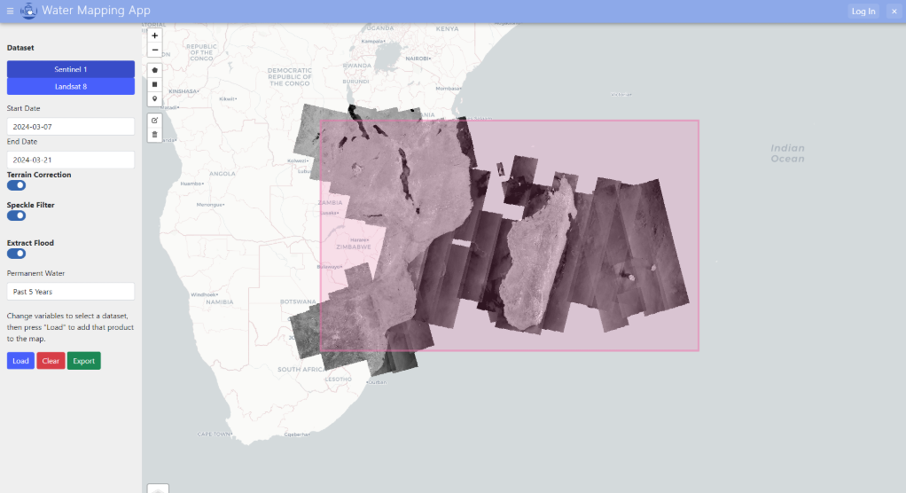
The Water Mapping App, developed by Kel Market and Kailey Mohamed, demonstrates how Tethys Platform can transform complex remote sensing data into clear, actionable information. This application leverages the HYDRAFloods Python package to generate surface water maps derived from satellite imagery in a given region. The underlying technology provides sensor-agnostic approaches to produce surface water maps, with workflows that utilize multiple remote sensing datasets in conjunction to deliver daily surface water information for flood applications.
What makes these applications effective isn’t just their technical sophistication but their focus on turning information into action. They present data in ways that support clear decisions, whether that’s evacuating flood-prone areas, allocating water resources, or planning for future environmental changes. By transforming complex scientific data into intuitive visualizations, these tools ensure that information becomes immediately accessible to those who need it most.
Real-World Applications
The GEOGLOWS Hydroviewer exemplifies this transformation. Developed by Riley Hales and Jorge Luis Sanchez, this application connects users to a geofabric of streams with forecasted streamflow from the ECMWF Global Streamflow Service. Rather than presenting raw data, the system translates complex hydrological information into intuitive visualizations that support flood preparation and water resource management.
In Nepal, the Flash Flood Prediction Tool takes this approach further by monitoring over 12,000 river segments and providing 54-hour flood forecasts. The system’s color-coded interface transforms complex data into clear risk indicators that communities can understand immediately:
- Blue for normal flow conditions
- Yellow for elevated risk
- Orange for high risk
- Red for severe risk
This visual approach ensures that technical information becomes immediately useful for local decision-makers, even without specialized training.
The Path Forward
As environmental challenges grow more complex, the need for effective data transformation becomes increasingly critical. Through thoughtful application development and user-centered design, we can ensure that Earth science data reaches those who need it most in forms they can readily use.
The success of these applications shows that the future of Earth science lies not just in collecting more data, but in developing more effective ways to use it. By focusing on this transformation, we help communities build more resilient and sustainable futures.
This Earth Day, we’re reminded that environmental stewardship requires not just understanding our planet, but providing communities with the tools to protect it. The democratization of environmental intelligence—making complex Earth science data accessible and actionable for all—represents one of the most promising pathways toward a more sustainable future.
Join Us in Creating Sustainable Solutions
The Tethys Geoscience Foundation provides a platform for Earth scientists to develop and share tools that make a difference. To learn more about our efforts and join our community of innovators, visit us on LinkedIn. Together, we can continue developing tools that help communities transform data into action.
Leave a Reply