Your cart is currently empty!

How Tethys Platform Transforms Water Resource Management
—
n the world of water resource management, the gap between data collection and effective decision-making remains a persistent challenge. Satellites monitor from above, river sensors collect data around the clock, and models predict everything from tomorrow’s streamflow to next year’s drought conditions. Despite this wealth of information, communities often struggle to translate these insights into action. The challenge isn’t a lack of data, it’s making that data accessible and meaningful for those who need to act on it.
The Decision-Making Dilemma
Water resource managers face increasingly complex decisions during challenging climate events. They must balance competing demands for limited water supplies while preparing for both flood and drought conditions. These decisions require not just data, but contextual understanding that connects environmental information to real-world outcomes.
Consider a regional water authority facing potential drought conditions. Raw data about precipitation deficits and reservoir levels might indicate a problem, but effective response requires transforming this information into answers to practical questions: Which communities face the greatest risk? When should water conservation measures begin? How should limited supplies be allocated among competing needs?
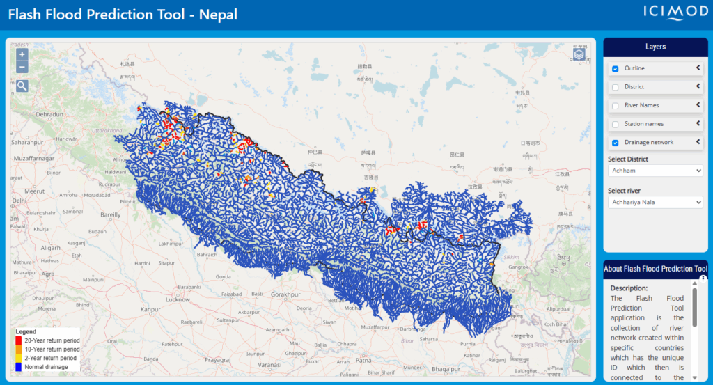
The Flash Flood Prediction Tool for Nepal exemplifies this transformation from data to decision support. Rather than simply providing raw streamflow data for 12,000 river segments, the system translates complex hydrological information into a color-coded risk assessment that decision-makers can immediately understand and act upon. The intuitive blue-to-red scale indicates flood risk levels, allowing local officials without specialized hydrological training to quickly identify areas of concern and allocate resources appropriately.
Creating Decision-Ready Information
Effective water management tools must bridge the gap between scientific understanding and practical action. This transformation happens at multiple levels:
Contextualizing data within local knowledge: Applications must integrate scientific data with local context, including infrastructure capabilities, population distribution, and historical patterns. The National Water Center’s Operations Dashboard achieves this by enabling operators to create custom views of hydrometeorological data that reflect their specific responsibilities and regional concerns.
Visualizing complex relationships: Water systems involve complex relationships between precipitation, groundwater, surface water, and human infrastructure. Effective applications help users visualize these relationships in ways that highlight key decision points. Rather than overwhelming users with all available information, well-designed interfaces reveal additional detail progressively, ensuring that comprehensive information remains accessible without causing cognitive overload.
Connecting information to action: Perhaps most importantly, effective applications connect environmental data directly to potential actions. They don’t just report conditions – they support the evaluation of alternatives and the selection of appropriate responses. By organizing visualization services logically and enabling custom dashboard creation, applications help users focus on the most relevant data for their immediate needs.
From Awareness to Action
The evolving approach to water resource applications reflects a broader shift in environmental management. Early environmental information systems focused primarily on monitoring and reporting conditions. Today’s applications increasingly emphasize decision support. They help users not just understand what’s happening, but determine what should be done in response.
This evolution parallels the changing nature of environmental challenges themselves. As climate patterns shift and populations grow, water managers can rely less on historical patterns and must increasingly navigate unprecedented conditions. In this context, applications that support adaptive decision-making become essential tools for resilient water management.
The GEOGLOWS Hydroviewer demonstrates this evolution. By connecting users to a global network of streams with forecasted streamflow, the system enables water managers to anticipate changes and adjust plans accordingly. The application transforms complex hydrological forecasts into intuitive visualizations that support both immediate decisions and longer-term planning.
Building Better Decision-Making Tools
Creating applications that effectively support decision-making requires more than technical sophistication. It demands a deep understanding of how decisions are made in practice and what information decision-makers need at different stages of the process. This understanding comes from close collaboration between developers, scientists, and the communities they serve.
As we continue developing water resource applications, several principles can guide our efforts:
- Focus on decisions, not just data: Begin by understanding what decisions users need to make, then work backward to determine what information would support those decisions.
- Respect different levels of expertise: Design interfaces that serve both technical and non-technical users, providing both simplified overviews and detailed information when needed.
- Connect to existing workflows: Ensure that applications integrate with how users already work, rather than requiring them to adopt entirely new processes.
- Allow for uncertainty: Water management often involves making decisions under uncertainty. Applications should help users understand the range of possible outcomes and make robust decisions despite incomplete information.
The Path Forward
As environmental challenges grow more complex, the need for effective decision support tools becomes increasingly critical. Through thoughtful application development and user-centered design, we can ensure that Earth science data reaches those who need it most in forms they can readily use.
The success of applications like the Flash Flood Prediction Tool and the GEOGLOWS Hydroviewer shows that the future of water resource management lies not just in collecting more data, but in developing more effective ways to use it. By focusing on this transformation from data to decision-making, we help communities build more resilient and sustainable water futures.
The Tethys Geoscience Foundation provides a platform for Earth scientists to develop and share tools that make this transformation possible. By joining our community, you can contribute to developing applications that help water managers make better decisions based on scientific understanding. Connect with us on LinkedIn to learn more about our efforts and become part of this important work.
Leave a Reply